I thought I would make a model of Carlisle Town, as I had earlier done with Edinburgh. The town in the 18th Century looked like this’

I thought I would make a model of Carlisle Town, as I had earlier done with Edinburgh. The town in the 18th Century looked like this’
This is the final part of my modelling Edinburgh as it was in 1745. My previous recent posts described modelling the town. This covers modelling the castle itself.
Edinburgh Castle in the mid-18th Century looked like this.

The ground around the castle was more open than it is now and the old city walls came right up to the castle. Many of the buildings on the southern and western sides of the castle had not yet been constructed.
Continue readingFollowing on from my last post on additional troops (Regular, Militia and Volunteer) to defend Edinburgh, my current project is making a model of the City and castle, starting with the City. In 1745 it looked like this:
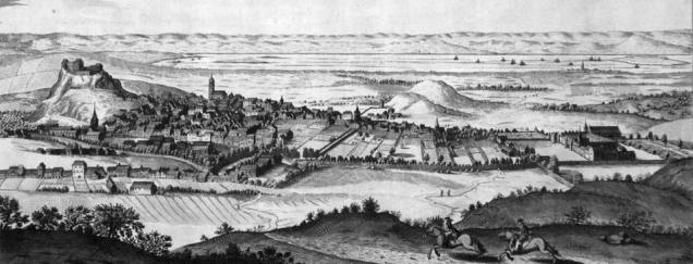
The castle is on the left (west) with the old town running down the ridge (now the Royal Mile) to Holyrood Palace on the right. There were almost no buildings of note north of the city until you reach the Forth.
Continue readingMinor raids were a feature of the Highland way of life, so I decided to model three of these which took place during the Jacobite Rebellion.

The first of these was against Culloden House in October 1745. Today Culloden House is a hotel and here is an old postcard of it.
Having captured both Fort George at Inverness and Fort Augustus, at the southern end of Loch Ness, the Jacobites moved on to the third Fort in the chain down the “Great Glen” formed by Loch Ness, Loch Lochy and Loch Linnhe. This was Fort William, which although constructed in a Vauban style was of a very irregular shape due to its position on the junction of Loch Linnhe and the River Nevis, as shown below.

In my last post I described how the Jacobites captured Fort George at Inverness in February 1746. They then moved south to besiege Fort Augustus, which was at the southern end of Loch Ness. This was a “modern” Vauban style fortress, with four bastions, but it suffered from a couple of fundamental flaws in its design. Here is an old print of it.

The “modern” Fort George is a Vauban style fortification to the north of Inverness, but this was built after the Jacobite Rebellion. In 1746, Fort George was the name given to the old medieval castle guarding the bridge to the south of Inverness. I decided I needed a Medieval castle to represent this, and explained how I created it in my last post.
The castle reverted to its original name of Inverness Castle after the Jacobite Rebellion and was considerably expanded in the 19th Century. However I found an old print of it in 1746 and realised that at that time it was mainly a keep plus curtain walls extending out along the banks of the River Ness towards the town.

All of the 19th Century extensions were built on the ground in front of the castle from this view.
I realised that I needed a medieval castle to represent Fort George in Inverness. The “modern” Fort George is a Vauban style fortification to the north of Inverness, but this was built after the Jacobite Rebellion. In 1746 Fort George was the name given to the original Inverness Castle, overlooking the bridge to the south of the city.

I looked around for various card medieval castles and decided that the Usborne one was most suitable for my needs. It is to the same 15mm scale which I use for all of my buildings, one size down from my 23mm (1:72) wargame figures.
It is designed to be made on a fixed pattern, stuck down to a 24″ x 18″ (60cm x 45cm) base. However I decided to make it in modular sections to give me more flexibility in its use.
I have decided to model the various forts which played a part in the Jacobite Rebellion. The first of these is Ruthven Barracks, which is in the Cairngorms, strategically placed to control the road from Perth towards either towards Inverness or Fort Augustus. Today the barracks looks like this:


I have two versions of a 15mm PaperTerrain Vauban Fortress, one the original and also the smaller one seen above, which has the original bastions (the diamond shaped corners), but half length walls and a modified gatehouse. I wanted glacis (the outer banks) for both of these, but felt that the PaperTerrain card ones were too steep an angle for my figures to stand on them, so I made my own. This blog describes how they were made. Continue reading
